

10th Mountain Division Hut to Hut
August 2022

Bald Mountain
The first day of the trip wasn’t a great start. I hiked two extra miles because I left my phone at the trailhead, but it was a beautiful day to hike from Broome Hut to Loveland. I suffered in the heat and threw up three times. I was still a little sluggish the next morning but felt better by the time I passed Arapahoe Basin.
I kept descending until Keystone and then turned south toward Breckenridge. During a thunderstorm, I was nervous about crossing under some power lines, but thankfully I never saw any flashes. The 48 miles between Broome Hut and Sister’s Cabin was the longest gap of the trip. The campsite I found next to a creek next to the Baker’s Tank was one of the best of the trip.
The cool morning and easy road walking helped me cover a ton of miles to Ken’s Cabin, Section House, and Francie’s Cabin before climbing through alpine meadows with wildflowers above Breckenridge and over the Ten Mile Range. The CDT above Copper was closed, so I got a burger from JJ’s in East Village. It was another hot afternoon traversing across Copper but the woods up to Janet’s were much better. I wandered up a herd path to find a campsite but found up at the back of Janet’s Cabin. As I tried to crest the ridge and get a look at the route ahead to Vail Pass, thunder and hail rolled in. I quickly hid below treeline and camped in a sheltered but not flat site.
Despite a clear and dry morning, the willows and swamps of the blue diamond route to Vail Pass. I adapted to finding the best route by reading the terrain and following a general direction rather than trying to follow my GPS track over the five miles until I got back to a trail. My gear dried out in about 15 minutes in the heat of the sun and then I got myself wet again on the blue diamond route to Shrine Mountain Inn’s three cabins. The route to Fowler-Hillard was far drier and easier to follow than the ones I was on in the morning. I bushwhacked down 2000’ over a mile to Resolution Creek Road and managed to avoid anything too steep or thick to get through. The road to get to the blue diamond route to Jackal Hut may have been harder with about 100 blowdowns covering a quarter mile of road. The climb was steep and challenging but the route was mostly apparent after the creek crossing. I took a road down to Camp Hale, connected to the CDT, and camped next to Fiddler Creek. I’d ignored a hot spot on my heel and wound up with a blister on my right heel.
The old road I took to Vance’s Cabin was slow and challenging to follow but I made much better time down to Ski Copper. I got confused in a place I have been to many times before and it took about ten minutes to find the way. I followed a road up to a ridge and dropped to the backside of Cooper to head towards Sangree’s. The route rolled repeatedly and felt much longer than it was in the summer heat. I took a more direct route to Tennessee Pass because the way there wasn’t fun and I saw some black clouds in the distance. Visiting my coworkers and snacking at TPNC was a highlight of my trip. After patching up my heels and leaving the nordic center, I passed Point Breeze and Continental Divide Cabins on the way to the 10th Mountain Hut. I was apprehensive about the route through seven drainages in less than three miles, but only one creek crossing involved wading through a stretch of willows. Once I got back onto the CDT, I found a nice campsite to get rained on all night.
I packed up my wet gear and tried tape over Band-Aids on my blistered heels before I started the day on the CDT. Beautiful views and easy hiking greeted me on the way to Uncle Bud’s Hut. There were thunderstorms in the forecast for the afternoon, so I was trying to get over Hagerman Pass before they rolled in. I dropped to Turquoise Lake and then faced a steep and challenging climb up Glacier Creek to Skinner Hut. After the hut, I rushed over Hagerman Pass and then dropped to a road in time to beat the storms. Once I was below treeline, I stopped to dry out some gear and then went to Betty Bear Hut. There was one more mile of the blue diamond route before I started an 8.5 mi road walk to end the day. I got poured on for about a half-hour into Chapman while hearing lightning within a mile or two. The tape over the bandaids on my heels came loose in the deluge and I could feel it rubbing under the balls of my ankles but didn’t feel comfortable stopping to do anything about it in the storm. By the time I got to the campground, I was absolutely drenched. My heels looked terrible. I made some soup to warm up but still spent a damp and chilly night under the tarp.
I was up and out of camp early because I was cold and all my gear was wet. My blister strategy was Vaseline only after the day before. The trailhead away from the campground wasn’t where it was marked on the map and it took my morning brain a while to find it. Once I did, it was an easy morning stroll to Margy’s Hut. My feet never dried out all day, but the rest of my stuff got drier throughout the day. I’d followed real trails that actually existed and roads all day for a change until I got to the McNamara spur. It was one of the easiest-to-follow blue diamond routes on my trip. About a mile in, it became so nice that I spent a few minutes looking for a worse trail before continuing. My feet got drenched again right before McNamara but everything else was getting drier despite some showers throughout the day. It was all roads and town trails down to Aspen. Once in town, I got some giant pizza slices and a beer before heading to St. Moritz Lodge. The shower, bed, and space to dry out felt super luxurious.
I woke up dry, relatively clean, and energized, but spent some time writing and route planning before heading out. I stopped at City Market and bought some Gatorade, Doritos, Icy Hot, and a comically large 13 oz tub of Vaseline. I meandered up the trail to Ute Rock and then the top of the Ajax lift at 11,209’. Once I got there at 10:30 am, I ate a cheesesteak, wrote some more, checked the weather, and finally left around noon. I still had at least 20 miles to go for the day, but being above treeline later seemed like the better move with the forecast. Once I got away from the resort, I dropped to just under 9000’ over four miles then followed a paved road for six. It was hot and sunny but I was moving quickly. Some passing clouds made things better as l did an easy out and back for about two miles each way to Lindley Hut on Copper Creek Rd. Once l got back to Pearl Pass Rd I started the long climb up to Pearl Pass. About halfway up, I got to Tagert and Greene-Willson Huts. I reached Pearl Pass around 7 pm and started the descent towards Friends Hut. The hut was visible from about halfway through the descent across a stunning alpine meadow. Of course, the last bit was a wet fight through willows, and I smashed my left knee on a rock about a thousand feet from the hut. My feet had been dry all day. I was exhausted after 8400’ of climbing for the day and fell asleep watching the stars using my tarp as a blanket.
It was cold and clear when I woke up and started towards the Bush Creek Trail from Friends Hut. I saw some frost once on plants once I got into an open meadow and I kept my layers on until around 9 am. Opa’s Taylor was one of the newest and most beautiful huts I visited on the whole trip, about six miles into the day. After couple miles along the road from Opa's, I turned onto Express Creek Road & dropped to 10.5k' over 2 more miles to get to Markley, then came back up and headed north to Gold Hill Rd to roll over some hills to Goodwin-Greene. I was loving the weather after so many rainy days, but I was starting to struggle with cramping pain in the inside of my right quad by my knee as I was going downhill. Once I got back onto Richmond Hill Road, I hobbled 3.5 mi to Barnard. By this time, my quad hurt going up and down, and it wasn’t much better on flat ground. The 6.8 mi back to Ajax barely rolled, with about 1100’ of up and down, but it took me almost 3 hours. I filtered some water shortly after Barnard and figured I would find another before the end of the day. No luck. It didn’t seem like I would be able to tolerate the full 3300’ descent, so I stopped and camped near the end of the National Forest land above Bingo Glades at 9:20 pm with about a quarter liter of water. I ate a bunch of Doritos and fruit snacks because I couldn't cook, and was in zero pain when I wasn’t walking.
I saved a few sips of water for the morning and continued descending to Aspen. My quad felt better than the night before, but I was still in a ton of pain. Some Ricolas and Juicy Burst Fruit Snacks kept the no-water situation manageable until I got to the trailhead just below 8000’, where I could drink. I took a bus from CO 82 into Aspen and back to pick up a maildrop and eat breakfast, then headed towards Smuggler Mountain Road. I was a sight, barely able to walk up the road, and filthy. The Aspen morning dog walkers weren't very friendly for some reason. I stopped to put some lcy Hot on my quad and finally took some Aleve as I began the 3.8 mi out and back to Fritz & Fabi's. My leg was starting to feel a lot better after the Aleve. There were showers around to the south and I'd heard a few rumbles of thunder. The weather had looked to be getting better, so I didn’t put my rain jacket on and it started to rain on the way back. I put it on as the hail came. I failed to perform the silly superstition of wearing rain gear to keep the storms away, but I would not be fooled again. After the 3.8 miles back, I began the long trek north towards the Vail area and Eiseman Hut. The wildflowers in the Aspen area were the best I’d seen on the trip. My quad still didn't feel great, but it had gotten much, much better since taking the Aleve. It was several hours of roads up and down to get to the Rocky Fork Trail, then a connector trail towards Miller Creek Trail. I stopped for the day when I couldn't figure out where the split for the trail down was. Once I had made camp, I noticed my knee was twice the size of the left one, so probably good I stopped. It still didn't hurt at all when I wasn't moving and felt better than the day before.
My knee was still swollen when I woke up, but it looked better. I took some more Aleve before heading down towards Frying Pan Road because it was working. After just over 6 miles, I got to the low point of the day at 8100’ on Frying Pan Road. When I reached the split to head to Harry Gates, the rancher who owned the property along the road told me to tell his horses to come home if I saw them. I said that I would. About 1.7 miles later, I found the horses and a few ran toward me. I spent a few minutes petting the friendly horsies and snapping selfies with them. When I started hiking again, I told them to go home as promised I would. Nothing exciting happened over the next 5.4 miles to Harry Gates Hut. After Crooked Creek Reservoir, I followed a path that led around some private property to what I thought would be a horse trail. It was fine for 0.1 miles, then I lost the path and wandered up the creek. It was going incredibly poorly, so I cut uphill until I found the blue diamonds for the Little Lime Creek Ridge Route. It would add some mileage, but it existed, so it was an improvement. My leg hurt and I was just annoyed in general as I hiked by the Peter Estin Hut and down the Ironedge Trail. I took a road to Newcomer Spring Trail, then the last blue diamond route of the trip to Polar Star Inn and Seipel Hut. I had to make a decision on the descent route. I could follow the 3.6 mi trail down, or bushwhack about 1.8 mi down a gully. There was about an hour of daylight left and the trail wasn't on all the maps I looked at, so I went with the short way. After a slow and painful descent through blowdowns and creekbeds, I got into a large meadow that led to the trail. I guess I let my guard down because I immediately went head over heels into a briar patch when I took my first step out of the woods. I expected to be bleeding from everywhere but escaped mostly unscathed. It was only 0.2 mi to the trail once I got myself put together again. I needed my lamp within a few minutes of getting to the trail and I made it through the bushwhack, so it seemed to be the right call It was mostly dark by the time I finished the last 0.4 mi to West Lake Creek Road and found a place to camp.
I woke up and told myself that today was the reward for the work that I'd put in throughout the trip. It would be almost entirely roads, there were multiple towns, and only 4300' of climbing. My quad was still sore but was improving and had become less swollen to the point it could almost pass for normal. I got rained on steadily for about the last five of the nine miles into Edwards. I ate a hunk of pizza and some Cheddar Fries with strawberry milk when I got to a Circle K. I meandered through a shopping center and then jumped on the rec path towards Avon. After a little over 7 miles, I reached the Vail Brewing Company and got a beer. Also got a burrito from the Rocky Mountain Taco Truck on the patio. I loved the Alambre filling- carne asada, bacon, cheese, chorizo, onions, and red, yellow, and green bell peppers. It was 3.5 more miles to shopping centers in West Vail. I wanted a beer to have at Eiseman, so I stopped at Safeway and got an Ecliptic Carina Peach Sour. At Red Sandstone Road, I finally left the rec path I had been on since Edwards. The day had gotten nicer and I had completely dried out. Thinking about how I was down to single-digit miles left was surreal. I had developed the same kind of pain that I'd had for the last four days in my right quad on the left. My right leg still hurt but has been looking and feeling better since it swelled up, so I didn't care. Most of the way left was dry, but of course, I had to get my feet soaked on the last stretch of hiking on a trail. All I would do was laugh. At 7:28 pm, I got to Eiseman. 36 huts, 322.8mi, 65,790’ of elevation gain over 11 days, 11 hours, and 2 minutes, I drank my beer on the deck and I was done.

Huts and route
Jump to:
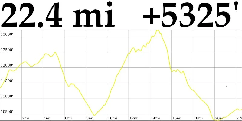
8/10 (Wed) - Broome Hut → Loveland - 22.5 mi - ↑ 5325’
8/11 (Thu) - Loveland → Baker's Tank - 30.5 mi - ↑ 4885’
8/12 (Fri) - Bakers Tank → Guller Greek Trail - 27.1 mi - ↑ 5597’
8/13 (Sat) - Guller Greek Trail → Fiddler Creek Campsite - 28.4 mi - ↑ 5190’
8/14 (Sun) - Fiddler Creek Campsite → CDT campsite - 22.3 mi - ↑ 5147’
8/15 (Mon) - CDT Campsite → Chapman CG - 24.1 mi - ↑ 3537’
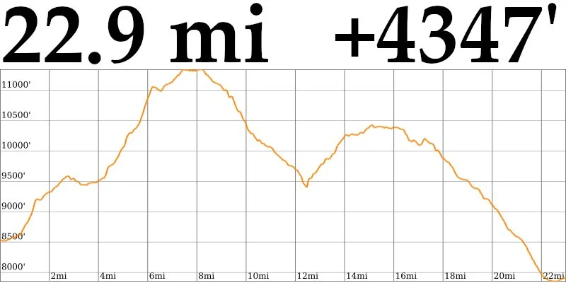
8/16 (Tue) - Chapman CG → Aspen - 22.9 mi - ↑ 4347'
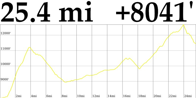
8/17 (Wed) - Aspen → Friends Hut - 25.4 mi - ↑ 8041'
8/18 (Thu) - Friends Hut → Ute Trail - 28.4 mi - ↑ 5558'
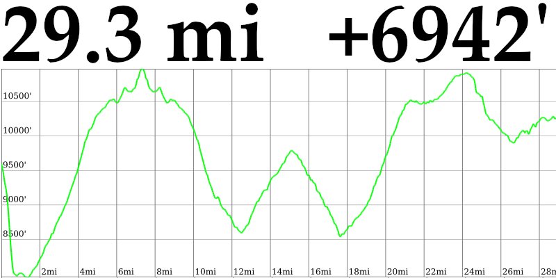
8/19 (Fri) - Ute Trail → Miller Creek Trail - 29.3 mi - ↑ 6942’
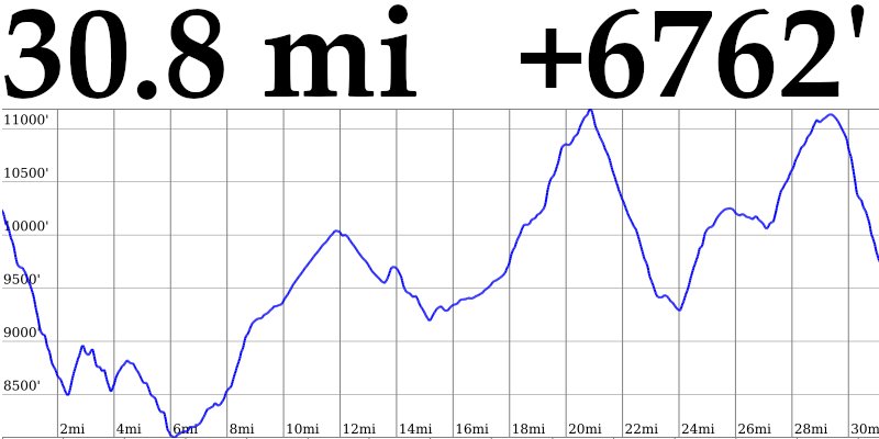
8/20 (Sat) - Miller Creek Trail → New York Mountain Trail - 30.8 mi - ↑ 6762’
8/21 (Sun) - New York Mountain Trail → Eiseman Hut - 31.5 mi - ↑ 4639’

Star Peak and Crystal Peak
8/10 (Wed) - Broome Hut → Loveland - 22.5mi - ↑ 5325’
Huts: Broome (#1 - 08:26)
The first day of the trip wasn’t a great start. I hiked two extra miles because I left my phone at the trailhead, but it was a beautiful day to hike from Broome Hut to Loveland. I suffered in the heat and threw up three times. I was still a little sluggish the next morning but felt better by the time I passed Arapahoe Basin.

Broome Hut
8/11 (Thu) - Keystone → Baker's Tank - 30.5mi - ↑ 4885’

Huts: Sister’s - (#2 - 18:05)
I was still a little sluggish the next morning but felt better by the time I passed Arapahoe Basin. I kept descending until Keystone and then turned south toward Breckenridge. During a thunderstorm, I got hailed on and was nervous about crossing under some power lines, but thankfully I never saw any flashes. 48 miles between Broome Hut and Sister’s Cabin was the longest gap between huts on the route. The campsite I found next to a creek next to the Baker’s Tank was one of the best of the trip.

Sister’s Cabin
8/12 (Fri) - Bakers Tank → Guller Greek Trail - 27.1 mi - ↑ 5597’

Huts: Section House (#3 - 07:13), Ken’s Cabin (#4 - 07:13), Francie’s Cabin (#5 - 10:43), Janet’s Cabin (#6 - 18:49)
A beautiful sunrise over Bald Mountain greeted me as I broke down camp and packed up. I was still a little sluggish the next morning but felt better by the time I passed Arapahoe Basin. I kept descending until Keystone and then turned south toward Breckenridge. During a thunderstorm, I got hailed on and was nervous about crossing under some power lines, but thankfully I never saw any flashes. 48 miles between Broome Hut and Sister’s Cabin was the longest gap between huts on the route. The campsite I found next to a creek next to the Baker’s Tank was one of the best of the trip.

Section House
8/13 (Sat) - Guller Greek Trail → Fiddler Creek Campsite - 28.4 mi - ↑ 5190’

Huts: Jay’s (#7 - 10:55), Chuck’s (#8 - 10:56), Walter’s (#9 - 11:03), Fowler-Hillard (#10 - 13:35), Jackal (#11 - 16:39)
I was still a little sluggish the next morning but felt better by the time I passed Arapahoe Basin. I kept descending until Keystone and then turned south toward Breckenridge. During a thunderstorm, I got hailed on and was nervous about crossing under some power lines, but thankfully I never saw any flashes. 48 miles between Broome Hut and Sister’s Cabin was the longest gap between huts on the route. The campsite I found next to a creek next to the Baker’s Tank was one of the best of the trip.

Fowler-Hillard Hut
8/14 (Sun) - Fiddler Creek Campsite → CDT campsite - 22.3 mi - ↑ 5147’

Huts: Vance’s (#12 - 07:46), Sangree’s(#13 - 10:51), Point Breeze(#14 - 15:22), Continental Divide (#15 - 15:23), 10th Mountain Hut (#16 - 17:21)
The old road I took to Vance’s Cabin was slow and challenging to follow but I made much better time down to Ski Copper. Then I lost some time because I got confused in a place I have been to many times before and it took about ten minutes to find the correct way. I followed a road up to a ridge and dropped to the backside of Cooper to head towards Sangree’s. The route rolled repeatedly and felt much longer than it was in the summer heat. I took a more direct route down to Tennessee Pass because the way there wasn’t fun and I saw some black clouds in the distance. Visiting my coworkers and snacking at TPNC was a highlight of my trip. After patching up my heels and leaving the nordic center, I passed Point Breeze and Continental Divide Cabins on the way to the 10th Mountain Hut. I was apprehensive about the route through seven drainages in less than three miles, but only one creek crossing involved wading through a long stretch of willows. Once I got back onto the CDT, I found a nice campsite to get rained on all night.

10th Mountain Hut
8/15 (Mon) - CDT Campsite → Chapman CG - 24.1 mi - ↑ 3537’

Huts: Uncle Bud’s (#17 - 08:18), Skinner (#18 - 11:38), Betty Bear (#19 - 13:35)
I packed up my wet gear and tried tape over Band-Aids on my blistered heels before I started the day on the CDT. Beautiful views and easy hiking greeted me on the way to Uncle Bud’s Hut. There were thunderstorms in the forecast for the afternoon, so I was trying to get over Hagerman Pass before they rolled in. I dropped to Turquoise Lake and then faced a steep and challenging climb up Glacier Creek to Skinner Hut. After the hut, I rushed over Hagerman Pass and then dropped to a road in time to beat the storms. Once I was below treeline, I stopped to dry out some gear and then went to Betty Bear Hut. There was one more mile of the blue diamond route before I started an 8.5 mi road walk to end the day. I got poured on for about a half-hour into Chapman while hearing thunder within a mile or two. The tape over the bandaids on my heels came loose in the deluge and I could feel it rubbing under the balls of my ankles but didn’t feel comfortable stopping to do anything about it in the storm. By the time I got to the campground, I was absolutely drenched. My heels looked terrible. I made some soup to warm up but still spent a damp and chilly night under the tarp.

Skinner Hut
8/16 (Tue) - Chapman CG → Aspen - 22.9mi - ↑ 4347'
Huts: Margy’s (#20 - 11:03), McNamara (#21 - 13:48)
I was up and out of camp early because I was cold and all my gear was wet. My blister strategy was Vaseline only after the day before. The trailhead away from the campground wasn’t where it was marked on the map and it took my morning brain a while to find it. Once I did, it was an easy morning stroll to Margy’s Hut. My feet never dried out all day, but the rest of my stuff got drier throughout. I’d followed real trails that actually existed and roads all day for a change until I got to the McNamara spur. It was one of the easiest-to-follow blue diamond routes on my trip. About a mile in, it became so nice that I spent a few minutes looking for a worse trail before continuing. My feet got drenched again right before McNamara but everything else was getting drier despite some showers throughout the day. From there, It was all roads and well-maintained trails down to Aspen. Once in town, I got some giant pizza slices and a beer before heading to St. Moritz Lodge. The shower, bed, and space to dry out felt super luxurious.
Margy’s Hut
8/17 (Wed) - Aspen → Friends Hut - 25.4 mi - ↑ 8041'
Huts: Lindley (#22 - 16:04), Tagert (#23 - 17:50), Greene-Wilson (#24 - 17:56), Friends (#25 - 20:08)
I woke up dry, relatively clean, and energized, but spent some time writing and route planning before heading out. I stopped at City Market and bought some Gatorade, Doritos, Icy Hot, and a comically large 13 oz tub of Vaseline. I meandered up the trail to Ute Rock and then the top of the Ajax lift at 11,209’. Once I got there at 10:30 am, I ate a cheesesteak, wrote some more, checked the weather, and finally left around noon. I still had at least 20 miles to go for the day, but being above treeline later seemed like the better move with the forecast. Once I got away from the resort, I dropped to just under 9000’ over four miles then followed a paved road for six. It was hot and sunny but I was moving quickly. Some passing clouds made things better as l did an easy out and back for about two miles each way to Lindley Hut on Copper Creek Rd. Once l got back to Pearl Pass Rd I started the long climb up to Pearl Pass. About halfway up, I got to Tagert and Greene-Willson Huts. I reached Pearl Pass around 7 pm and started the descent towards Friends Hut. The hut was visible from about halfway through the descent across a stunning alpine meadow. Of course, the last bit was a wet fight through willows, and I smashed my left knee on a rock about a thousand feet from the hut. My feet had been dry all day. I was exhausted after 8400’ of climbing for the day and fell asleep watching the stars using my tarp as a blanket.

Greene-Wilson Hut
8/18 (Thu) - Friends Hut → Ute Trail - 28.4 mi - ↑ 5558’

Huts: Opa's Taylor (#26 - 10:31), Markley (#27 - 12:50), Goodwin-Green (#28 - 14:34), Barnard (#29 - 16:49)
It was cold and clear when I woke up and left Friends Hut. I saw some frost once on plants once I got into an open meadow and kept my layers on until around 9 am. Opa’s Taylor was one of the newest and most beautiful huts I visited, about six miles into the day. After couple miles along the road from Opa's, I dropped to 10.5k' to get to Markley Hut, then came back up and headed north to roll over some hills to Goodwin-Greene. I was loving the weather after so many rainy days, but starting to struggle with a sharp, cramping pain in the inside of my lower right quad as I was going downhill. Once I got back onto Richmond Hill Road, I hobbled to Barnard Hut. By this time, my quad hurt going up and down, and it wasn’t much better on flat ground. The 6.8 mi back to Aspen barely rolled but took me almost 3 hours. I filtered some water shortly after Barnard and figured I would find another source before the end of the day. No luck. It didn’t seem like I would be able to tolerate the full 3300’ descent, so I stopped and camped near the end of the National Forest land above Bingo Glades at 9:20 pm with about a quarter liter of water. I ate a bunch of Doritos and fruit snacks because I couldn't cook, and was in zero pain when I wasn’t walking.

Opa's Taylor Hut
8/19 (Fri) - Ute Trail → Miller Creek Trail - 29.3 mi - ↑ 6942’
Huts: Fritz's (#30 - 12:36), Fabi’s (#31 - 12:37)
I saved a few sips of water for the morning and continued descending to Aspen. My quad felt better than the night before, but I was still in a ton of pain. Some Ricolas and Juicy Burst Fruit Snacks kept the no-water situation manageable until I got to the trailhead, where I could drink. I took a bus from CO 82 into Aspen and back to pick up a maildrop and eat breakfast, then headed towards Smuggler Mountain Road. I was a sight, barely able to walk up the road, and filthy. The Aspen morning dog walkers weren't very friendly for some reason. I stopped to put some lcy Hot on my quad and finally took some Aleve as I began the out and back to Fritz & Fabi's. My leg was starting to feel a lot better. There were showers around to the south and I'd heard a few rumbles of thunder. But the weather looked to be getting better, so I didn’t put my rain jacket on and it started to rain on the way back. I put it on as the hail came. I failed to perform the silly superstition of wearing rain gear to keep the storms away, but I would not be fooled again. After Fritz & Fabi's, I began the long trek north towards the Vail area and Eiseman Hut. The wildflowers in the Aspen area were the best I’d seen on the trip. My quad still didn't feel great, but it had gotten much, much better since taking the Aleve. It was several hours of roads up and down to get to the Rocky Fork Trail, then a connector trail towards Miller Creek Trail. I stopped for the day when I couldn't figure out where the split for the trail down was. Once I had made camp, I noticed my knee was twice the size of the left one, so probably good I stopped. It still didn't hurt at all when I wasn't moving and felt better than the day before.

Fritz & Fabi’s

8/20 (Sat) - Miller Creek Trail → New York Mountain Trail - 30.8 mi - ↑ 6762’
Huts: Harry Gates (#32 - 12:43), Peter Estin (#33 - 15:32), Siepel (#34 - 19:18), Polar Star Inn (#34 - 19:19)
My knee was still swollen when I woke up, but it looked better. I took some more Aleve before heading down towards Frying Pan Road because it was working. When I reached the split to head to Harry Gates, the rancher who owned the property along the road told me to tell his horses to come home if I saw them. I said that I would. About 2 miles later, I found them and a few ran toward me. I spent a few minutes snapping selfies and petting the friendly horsies. When I started hiking again, I told them to go home as promised I would. Nothing exciting happened the rest of the way to Harry Gates Hut. After Crooked Creek Reservoir, I followed a path that led around some private property to what I thought would be a horse trail. It was fine for 0.1 miles, then I lost the path and wandered up the creek. It was going incredibly poorly, so I cut uphill until I found the blue diamonds for the Little Lime Creek Ridge Route. It would add some mileage, but it existed, so it was an improvement. My leg hurt and I was just annoyed in general as I hiked by the Peter Estin Hut and down the Ironedge Trail. I took a road to Newcomer Spring Trail, then the last blue diamond route of the trip to Polar Star Inn and Seipel Hut. I had to make a decision on the descent route. I could follow the 3.6 mi trail down, or bushwhack about 1.8 mi down a gully. There was about an hour of daylight left and the trail wasn't on all the maps I looked at, so I went with the short way. After a slow and painful descent through blowdowns and creek beds, I got to a large meadow that led to the trail. I guess I let my guard down because I immediately went head over heels into a briar patch when I took my first step out of the woods. I expected to be bleeding from everywhere but escaped mostly unscathed. It was only 0.2 mi to the trail once I got myself put together again. I needed my headlamp within a few minutes of getting to the trail but made it through the bushwhack, so it seemed to be the right call. It was mostly dark by the time I got down to West Lake Creek Road and found a place to camp.
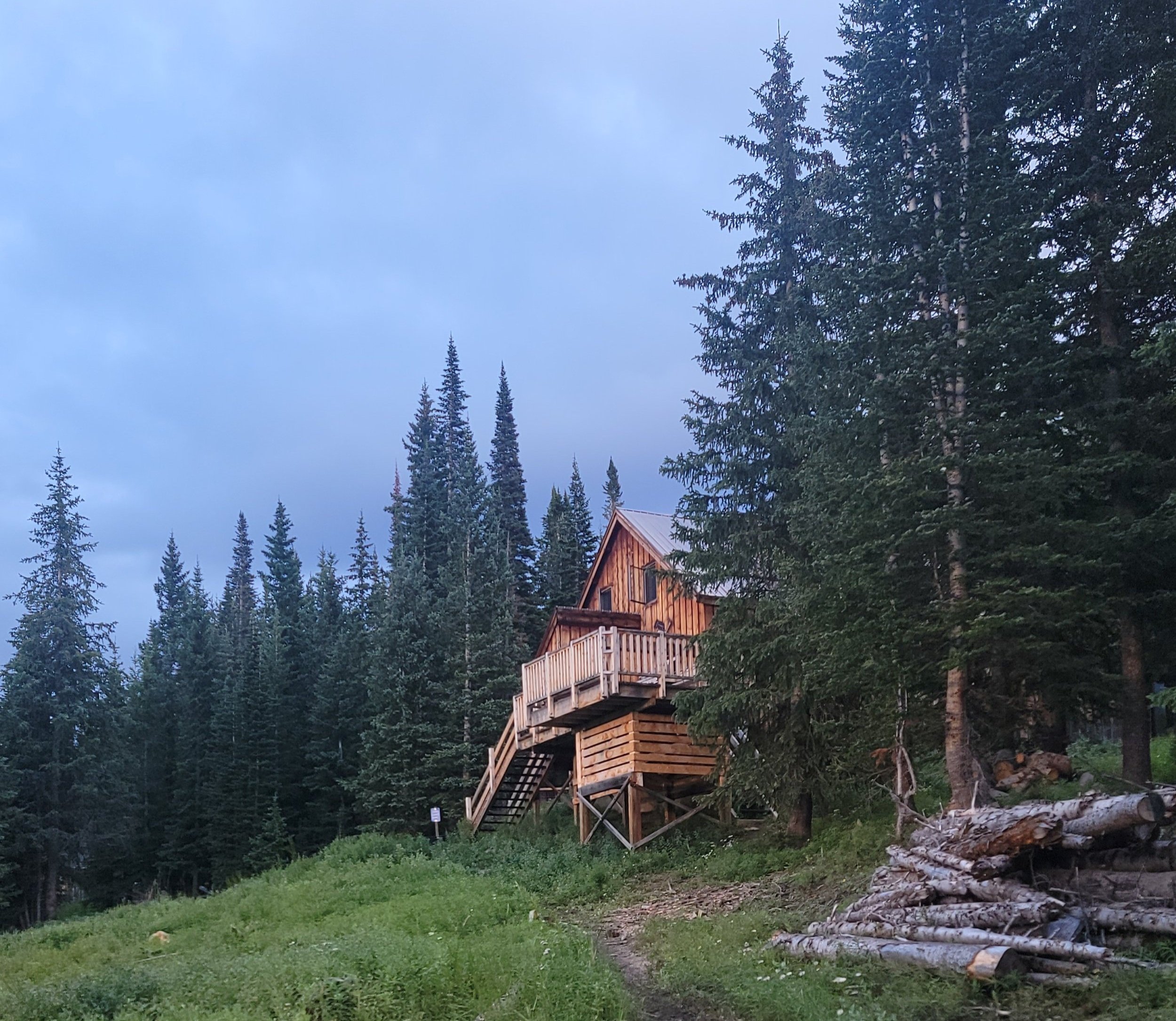
Siepel Hut
8/21 (Sun) - New York Mountain Trail → Eiseman Hut - 31.5 mi - ↑ 4639’

Huts: Eiseman (#36 - 19:54)
When I woke up, I told myself that this day would be the reward for the work that I'd put in throughout the trip. It would be almost entirely roads, there were multiple towns, and only 4300' of climbing. My quad was still sore but was improving and had become less swollen to the point it could almost pass for normal. I got rained on steadily for about the last five of the nine miles into Edwards. Once I got to a Circle K I ate a hunka pizza and some Cheddar Fries with strawberry milk. I jumped on the rec path towards Avon and stopped for a beer at Vail Brewing Company. Also got a burrito from the Rocky Mountain Taco Truck on the patio. I loved the Alambre filling- carne asada, bacon, cheese, chorizo, onions, and red, yellow, and green bell peppers. I kept going to West Vail and wanted a beer to have at Eiseman, so I stopped at Safeway and got an Ecliptic Carina Peach Sour. At Red Sandstone Road, I finally left the rec path I had been on since Edwards. The day had gotten nicer and I had completely dried out. Thinking about how I was down to single-digit miles left was surreal. I had developed the same kind of pain that I'd had for the last four days in my right quad on the left. My right leg still hurt but has been looking and feeling better, so I didn't care. Most of the way left was dry, but of course, I had to get my feet soaked on the last stretch of hiking on a trail. All I could do was laugh. At 7:28 pm, I got to Eiseman. 36 huts, 322.8mi, 65,790’ of elevation gain over 11 days, 11 hours, and 2 minutes, I drank my beer on the deck and I was done.

Eiseman Hut